June 25, 2026 • 5 min read
Evidence-first
master planning with remote sensing and AI

Martin Hedman
Building faster baselines and enabling informed early‑stage decisions for complex projects.
Most project risk is locked in before design begins.
Master planning is where those early decisions are made – often with incomplete data, competing constraints and limited time. The result is avoidable rework, cost escalation and schedule risk later in the project.
When done well, master planning reduces that risk. It creates a clear, evidence-based direction for a site, district or asset – allowing teams to test options early and make trade‑offs with confidence.
It helps teams answer practical questions before design decisions are locked in:
- What constraints can’t be ignored?
- Where are the opportunities worth exploring?
- What options should we test now to avoid expensive rework later?
- What sequence makes sense over the project lifecycle?
Across sectors, from industrial and energy developments to ports, transport corridors, and urban districts, we see a pattern.
Projects rarely fail because of detailed design. They fail because of decisions made earlier, when uncertainty is highest and evidence is weakest.
This is the point at which choices are locked in about feasibility, constraints, and trade offs that shape cost, schedule and delivery for years to come.
If the evidence is thin at that moment, every subsequent decision downstream will carry hidden risks.
Key takeaways
- Early-stage master planning is where risk is cheapest to remove
Better early evidence reduces late surprises and rework. - Remote sensing strengthens the baseline
It helps teams see terrain, water, land cover and change consistently across large areas. - Artificial intelligence can amplify remote sensing and planning
It supports feature extraction and faster synthesis, but it works best with human review and clear controls. - Credibility comes from transparency
Confidence levels, validation steps and clear assumptions matter as much as the tools. - Evidence-first planning supports better outcomes
It can help teams avoid constraints earlier and make trade‑offs clearer to decision makers.
Why early-stage evidence matters
Identifying constraints early – whether environmental, operational or legacy – gives teams the option to avoid or design around them before they become costly constraints. Equally, early identification of opportunities means they can be maximized rather than discovered too late to act on – whether that is latent capacity, underutilized land and infrastructure, or environmental conditions that support early restoration planning. Late discovery is where costs rise, timelines tighten and choices narrow.
That’s the gap remote sensing helps close.
In simple terms, remote sensing is the use of satellite or aerial imagery to observe and measure conditions on the ground without being physically present. It gives teams a consistent view of terrain, land cover, water dynamics and change over time, even when local data is incomplete.
It doesn’t replace on-the-ground knowledge, but it helps teams start from a shared baseline rather than assumptions. This matters because teams move from assumptions to evidence earlier – improving feasibility decisions and reducing downstream surprises.
Artificial intelligence builds on that foundation. It improves remote sensing outputs by detecting features and changes more efficiently and it helps planners synthesize more information into fewer, better decisions. When used well, it supports human judgment and makes early-stage master planning more transparent.
The fastest way to improve a master plan is to improve what you know at the start.

Example: NDVI, NDMI, True Color, NDMI and NDWI compilation/composite figure.
Remote sensing: A faster baseline for what’s really there
Remote sensing is most valuable when teams need a baseline quickly and consistently. It helps establish an early picture of conditions across large areas, especially during concept development, site selection and front-end planning.
In practical terms, it supports early-stage master planning by helping teams:
- map terrain and drainage patterns that affect access, constructability and risk
- understand land cover and how it has changed over time
- identify water extent and seasonal variability where that shapes feasibility
- create a repeatable baseline that can be updated as the plan evolves.
Working with a mining customer in Sub-Sharan Africa, we used satellite bands and derived indices to build an early baseline across a large-scale copper mining complex with decades of operational history. A ten-year time series of vegetation, moisture stress and surface water indices revealed progressive landscape decline, recurring water accumulation in operational zones, and shifting tailings conditions across thousands of hectares – patterns that would have not been visible from available records alone. This allowed the team to focus field verification on the areas that mattered most, reducing time on site and giving the wider project team a shared, evidence-based starting point.
“That’s the right mental model: remote sensing helps teams ask better questions earlier, then validate what matters.”
It’s also important to be clear about limits. Remote sensing doesn’t remove the need for local knowledge, ground truth, or engineering judgment. Resolution, cloud cover, data availability and context all matter. A credible baseline is transparent about confidence, assumptions and what still needs verification.
AI: Amplifying insight without replacing judgement
AI builds on this foundation in two ways. First, it enhances the process of remote sensing itself. Tools that support segmentation, classification, object detection and change detection help teams move from imagery to map‑ready layers more efficiently. That can reduce manual digitizing and make outputs more consistent across geographies, provided models are validated and used with clear controls.
Second, it supports the planning workflow. In master planning, AI is most valuable where it improves early decisions – helping teams process more inputs, compare options faster and make trade-offs more transparent. Early-stage master planning often involves a significant number of competing layers - environmental constraints, legacy assets, access, utilities, social considerations, regulatory requirements and competing priorities - with constraints on time to process them.
AI helps teams synthesize that complexity by:
- prioritizing constraints and opportunities based on agreed criteria
- highlighting anomalies or changes worth investigating
- comparing scenarios more consistently so trade-offs are clearer.
This is where human review matters. “Artificial intelligence should support decisions, not make them.” The outputs need traceability, confidence grading and review by people who understand the local and project context. That’s how teams gain speed without losing credibility.
In one project, we used AI‑derived datasets – including machine learning generated building footprints and road networks – to establish an alternative view of existing site surroundings where available mapping data was limited. These layers supplemented publicly available datasets and gave the team a more complete picture of what was on the ground. As with any derived dataset, the outputs were validated against imagery and local knowledge before informing planning decisions.
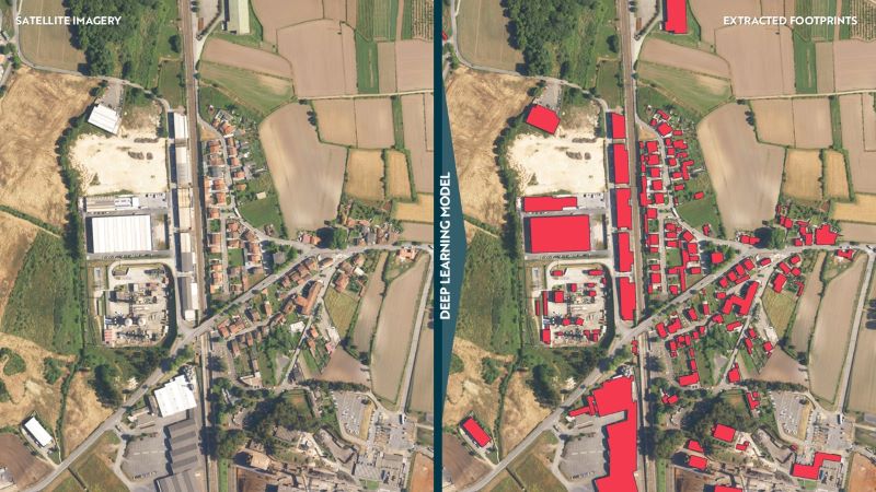
Example: segmentation overlay of extracted building footprints.
Developing a practical, evidence-first workflow
An evidence-first approach doesn’t need to be complex. A simple workflow is often enough to improve outcomes:
- Build a baseline: use remote sensing to establish consistent layers and trends.
- Validate what matters: apply local knowledge and targeted field checks.
- Turn evidence into options: develop a small set of viable scenarios.
- Compare trade-offs: apply agreed criteria, document assumptions against confidence levels.
- Keep it live: update the baseline as new information becomes available.
This approach supports better conversations with stakeholders because it makes the basis for decisions visible. “When teams can explain what they know, what they don’t and what they will verify next, master planning becomes more credible and easier to defend.”
Ready to start with evidence
Master planning is changing. Faster decisions are expected, with clearer trade‑offs, and more confidence that early decisions will hold up under scrutiny. In that environment, assumptions are no longer good enough. Remote sensing and artificial intelligence won’t replace expertise and judgment. But when applied with discipline, they raise the standard of evidence that early decisions rely on – helping leaders move faster without carrying hidden risk into cost, schedule and delivery.
If you’re entering concept development or site selection and need a clearer, evidence‑based starting point, we can help you assess where remote sensing and AI will make a measurable difference.
Sources
- European Space Agency, Sentinel missions overview (Copernicus). https://www.esa.int/Applications/Observing_the_Earth/Copernicus
- U.S. Geological Survey, Landsat missions overview. https://www.usgs.gov/landsat-missions
- UN-Habitat, International Guidelines on Urban and Territorial Planning (IG‑UTP). https://unhabitat.org/international-guidelines-on-urban-and-territorial-planning-ig-utp-handbook
Author bio

Martin Hedman is a Master Planner at Worley Consulting, working across industrial and urban master planning, including concept development, site selection, and feasibility work. They focus on evidence-led planning that helps teams make early-stage decisions clearer and more defensible, balancing delivery needs with long-term outcomes.